Public Buses, Car Rentals, Bike-Sharing, and Everything in Between
The golden coastline glistened under a mid-morning sun as I stepped onto Tauranga’s waterfront promenade. This vibrant harborside city on New Zealand’s North Island pulses with relaxed energy, sea breeze in the air, and a pace that balances serenity with a quiet hum of activity. Nestled in the Bay of Plenty, Tauranga is more than just a beachside escape—it’s a city that invites exploration in every direction, from coastal enclaves to inland hills and charming suburbs. Knowing how to move within this space enhances every part of the experience.
1. The First Impressions of Getting Around
As the wheels of the aircraft kissed the runway at Tauranga Airport, the question formed almost instinctively: What’s the best way to get around here?
In a city that blends urban infrastructure with natural topography, transportation takes on a character of its own. The choices are abundant: an expanding public bus network, accessible car rentals, user-friendly bike-share programs, and walkable urban pockets. But each option has its rhythm, its nuances, and its best use-case scenario. Understanding those subtleties unlocks not just convenience but connection—with places, people, and the pulse of Tauranga.
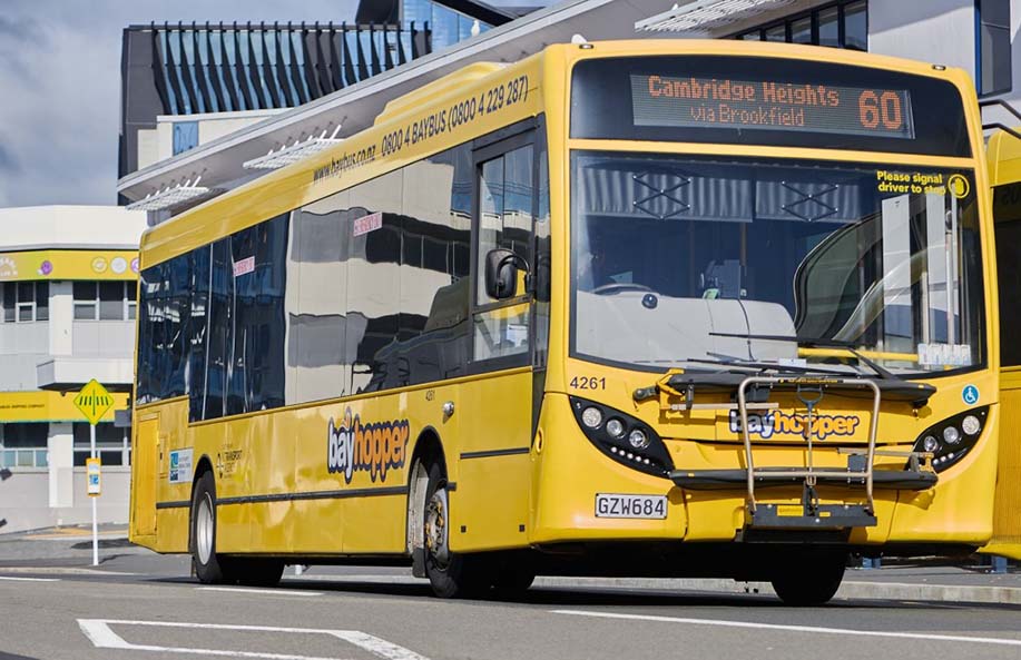
2. Riding the Buses: Bayhopper, the Backbone of Public Transit
Tauranga’s public bus system is operated under the name Bayhopper, managed by Bay of Plenty Regional Council. For anyone looking to travel affordably and sustainably, Bayhopper serves as the most extensive option.
Route Coverage and Reach
Bayhopper buses connect most of the urban and suburban sprawl of Tauranga, including:
- Tauranga CBD
- Mount Maunganui
- Papamoa
- Greerton
- Bethlehem
- Welcome Bay
- Tauriko Crossing (shopping & retail)
- Tauranga Hospital
Routes are numbered and color-coded for clarity. The 1, 2, and 5 buses cover major corridors between the CBD and coastal suburbs. Buses to Papamoa or Mount Maunganui are especially popular among beachgoers, digital nomads, and commuters alike.
Schedules and Frequency
The weekday bus schedule is relatively robust, with most major routes running every 30 minutes during peak hours. Weekend frequencies drop to every 60 minutes on average. Buses operate roughly between 6:00 AM and 10:00 PM, though some suburban routes finish earlier. Real-time updates are available through Transit App, a reliable companion for live tracking and planning.
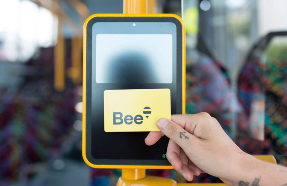
Payment and Bee Card System
Travelers have two payment options:
- Cash: Pay the driver directly.
- Bee Card: A contactless smart card used across multiple regional transit networks in New Zealand.
The Bee Card offers significant fare discounts compared to cash and is easily obtainable at bus depots or local convenience stores. One simply loads credit onto the card and taps on and off each ride.
Accessibility
Bayhopper buses are wheelchair-accessible, stroller-friendly, and equipped with ramps. Priority seating is clearly marked, and announcements are generally visible both visually and audibly.
3. Car Rentals: Freedom to Roam
For destinations off the beaten path or day trips beyond city limits, car rental becomes not just a convenience, but a strategic asset.
Where to Rent
Car rentals are available at Tauranga Airport, in the CBD, and through online aggregators. Well-known rental companies include:
- Hertz
- Avis
- Thrifty
- Budget
- GO Rentals
Local companies such as Wai Ora Rentals and Bay Rentals often provide more flexible rates and pickup/drop-off options.
Driving Conditions and Regulations
Tauranga enjoys well-maintained roads, moderate traffic (by New Zealand standards), and courteous drivers. Important driving reminders include:
- Always drive on the left side.
- Roundabouts are common—give way to the right.
- Urban speed limits hover around 50 km/h, while highways typically allow 100 km/h.
Parking in the CBD is metered, but most suburban beaches and shopping areas offer free parking. Mobile parking apps like PayMyPark allow for remote top-ups and digital tickets.
Scenic Drives to Consider
The real value of a rental unfolds in the following journeys:
- Tauranga to Rotorua: A geothermal-rich route through lush forestry (about 1 hour).
- Mount Maunganui to Waihi Beach: Coastal drive with sweeping views.
- Kaimai Ranges Loop: A mountain pass dotted with waterfalls and heritage trails.
These routes benefit from the flexibility only a private vehicle provides, especially for photography stops, picnic breaks, and spontaneous detours.
4. Shared Mobility: Bicycles and Scooters
Tauranga is actively embracing micro-mobility. With a network of bike lanes, shared paths, and promenade-friendly routes, cycling is increasingly viable.
Bike Sharing Programs
The main bike-share platform is Neuron Mobility, which operates both e-bikes and e-scooters.
How It Works
- Download the Neuron app.
- Register and add a payment method.
- Scan the QR code on a parked bike or scooter.
- Begin your ride and end it at designated parking zones.
Pricing is calculated per minute, with passes available for unlimited rides over a day or week. E-bikes are particularly helpful on Tauranga’s undulating terrain and in areas like Welcome Bay or Maungatapu.
Safety and Bike Infrastructure
Helmets are mandatory. Neuron provides one integrated into the bike’s handlebars. Bike lanes are marked in green and often buffered from traffic. Mount Maunganui and The Strand (in the CBD) are especially bike-friendly, with waterfront trails and wide pedestrian paths.
5. Walking: Compact, Scenic, and Rewarding
Many neighborhoods in Tauranga are best explored on foot. The Tauranga CBD, Mount Maunganui Base Track, and Pilot Bay are especially rewarding for pedestrians. These walks offer immersive experiences—street art, boutique cafes, native flora, and the slow unveiling of views that change with every corner.
Paved sidewalks, zebra crossings, and pedestrian signals are well-maintained. Trails like the Katikati Bird Walkway and Mauao Summit Track add a more nature-oriented dimension to walking.
6. Taxis and Ride-Sharing: A Supplement, Not a Staple
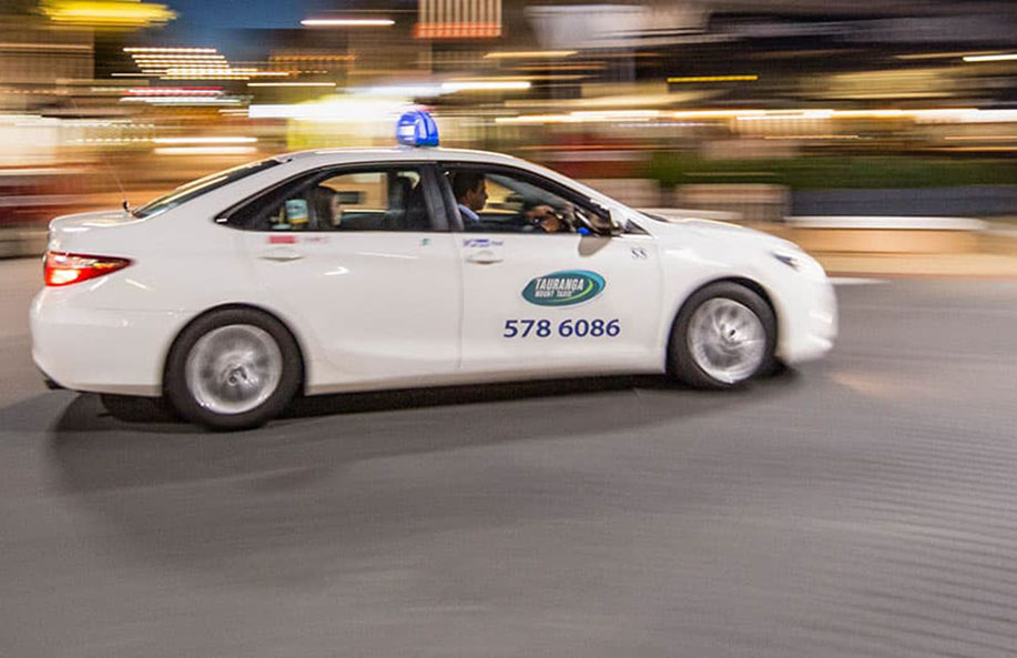
While available, taxis and ride-sharing services play more of a backup role in Tauranga compared to larger cities.
Options Available
- Tauranga Mount Taxis: Reliable, locally-owned.
- Uber: Operational but with limited coverage.
- Zoomy: A Kiwi-based ride-share app with variable availability.
Fares tend to be higher due to lower population density and fewer drivers on the road. They’re ideal for airport transfers, late-night travel, or direct trips between suburbs.
7. Ferry Services and Water Transport
Although Tauranga has a large harbor, regular passenger ferry services are limited. Private charters operate between The Strand Jetty and nearby islands or for marine tours. Kayak rentals and water shuttles provide leisure transport but aren’t practical for daily commuting.
8. Transport Hubs and Transfer Points
Several key locations act as transportation crossroads:
- Willow Street Bus Interchange (CBD): Main public transit hub.
- Bayfair Mall: Intersecting point for bus routes to Mount Maunganui and Papamoa.
- Tauranga Crossing: Retail-focused transit point for western suburbs.
Each hub includes real-time display boards, seating, shelter, and proximity to amenities. These hubs anchor the transport network and make multi-modal travel more cohesive.
9. Practical Tips for Seamless Travel
A few strategies help ensure smooth movement across the city:
- Use Transit Apps: Both Transit App and Moovit offer accurate schedules and trip planners.
- Travel Cards Save Time: The Bee Card works across multiple Bay of Plenty towns.
- Mind the Weather: Sudden rain showers can disrupt scooter and bike plans.
- Layer Up: Microclimates are common; Mount Maunganui can feel balmy while inland hills get brisk.
10. Planning Day Trips with Multi-Modal Access
Some of the best travel experiences come from combining transportation types. For instance:
- Bus to Mount Maunganui, bike along the coast, then rent a car for the evening drive to McLaren Falls Park.
- Walk Tauranga Art Gallery, bus to Greerton’s Heritage Village, then bike back along the estuary path.
- Scooter along The Strand, hike Mauao, and Uber back with tired legs.
This hybrid approach matches Tauranga’s layered landscape and lets each mode shine in its best context.
11. Anticipating the Future of Tauranga Transit
Tauranga’s population growth and increasing visitor numbers are steering investment into smarter, more integrated transit solutions. New rapid bus corridors, expanded bike superhighways, and long-term plans for light rail feasibility reflect the city’s transportation evolution.
Future-ready travelers can already benefit from the direction Tauranga is heading. Choosing eco-friendly transport methods contributes to sustainability goals, and every trip via bike, bus, or scooter helps ease road congestion and reduce emissions.
Even now, the sense of movement in Tauranga feels dynamic. There’s intention behind infrastructure upgrades, and a conscious effort to keep the city connected—not just geographically, but also communally.